
“Lost River Mountains” by Fredlyfish4 is licensed under CC BY-SA 4.0.
Idaho’s mountains stretch far and wide, but none stand taller than Mount Borah, a towering peak in the Lost River Range that rises to 12,662 feet. As one of the most unique things to do in Idaho, it offers the state’s highest point and a summit experience that draws thousands of hikers each year. Whether you’re a seasoned climber or simply in search of a big challenge, Mount Borah promises dramatic vistas, thrilling routes, and a sense of standing on top of Idaho’s world.
A Towering Presence in the Lost River Range

“Borah Peak, Lost River Range, Idaho ” by Sam Beebe/Ecotrust is licensed under CC BY-SA 3.0.
Located in central Idaho, the Lost River Range runs southeast from Challis toward Arco, featuring steep ridgelines and rugged summits that remain relatively undeveloped. Mount Borah forms the monarch of this range: at 12,662 feet, it dominates the skyline and draws climbers from across the country. The mountain’s profile, especially when viewed from the plains near Mackay, appears formidable, rising swiftly above rolling valleys before culminating in bare, gray limestone slabs near the top. Surrounded by wilderness areas, Borah also benefits from a certain solitude—though the standard trail does attract a fair number of visitors in high summer, it’s rarely overcrowded.
Because Borah is Idaho’s highest summit, it’s often on the radar of “highpointers” seeking to stand atop each state’s peak. Others come simply for the challenge of scaling a mountain that looms nearly 6,000 feet above its trailhead. The sense of scale is apparent as soon as you arrive: steep switchbacks gain altitude quickly, and the wide farmland below recedes with surprising speed, revealing an ever-broader view of high desert terrain and distant ranges.
A Brief History & Quake-Driven Rise

“194008XX-FS-Challis-AAM-400868” by Forest Service Photography is marked with Public Domain Mark 1.0.
Borah has long been recognized as the king of Idaho’s summits, but it wasn’t until early surveys in the 1900s that climbers began ascending it in earnest. The first recorded summit might have occurred around 1912 by T. M. Bannon, a USGS surveyor. In 1934, the peak was named for William Borah—a noted state senator known as the “Lion of Idaho.” Over the years, technical routes opened on various faces for climbers seeking more difficult lines, while a “standard” approach formed on the mountain’s southwestern flank.
In October 1983, the Lost River Range experienced a significant earthquake, famously raising Borah’s summit by several feet. Maps often list 12,655 or 12,662 as the peak’s elevation, but local lore suggests it could be slightly higher following that seismic event. Regardless of the minor variations, the summit box stands as the recognized top of Idaho, luring adventure seekers with the promise of breathtaking landscapes in every direction.
Getting There & Campground Basics

“Salmon-Challis National Forest Sign” by Raymond Hitchcock from Seattle, Washington, USA is licensed under CC BY-SA 2.0.
Mount Borah sits north of Mackay along Idaho’s Highway 93, about a two-and-a-half-hour drive from Idaho Falls or roughly three hours from Boise if you take scenic back roads. Look for Birch Springs or a small sign indicating Borah trailhead access. The mountain’s base area features a simple campground with around five sites. These come with picnic tables, fire rings, and vault toilets, but no hookups or potable water—visitors should arrive prepared with their own supplies.
Many climbers choose to arrive the evening before their ascent, sleeping at the trailhead so they can set off at dawn. Though the campground is small, the vibe is welcoming, with fellow climbers often sharing tips or swapping stories about other Idaho peaks. While there’s no entry fee or formal reservation system at Borah’s base, having a Plan B in mind is wise if the limited campsites fill up.
Prime Climbing Season

“Solidago multiradiata – Rocky Mountain goldenrod” by Matt Lavin is licensed under CC BY-SA 2.0.
The best window for tackling Borah typically runs from mid-July to mid-September. By then, most winter snows have melted, clearing the main route (known as the “southwest ridge” or “Chicken-Out Ridge”) of large drifts. Weather is also relatively stable—though storms can still sweep in unexpectedly. Attempting the climb outside this period often means dealing with snowfields, icy slopes, or significant avalanche hazard on steeper faces. Some advanced mountaineers do relish a cold-season ascent, bringing ice axes and crampons, but that requires extra caution and skill.
In peak season, expect moderate daytime highs in the valleys below, though the summit can be cold or windy. A typical day might begin with comfortable morning temperatures at the trailhead, shifting to cooler breezes near the top. Layers are essential: lightweight wicking shirts for the lower slopes, plus a windbreaker or down jacket for the summit. Early starts help climbers avoid potential thunderstorms that build up by afternoon and also reduce sun exposure in hotter weather.
The Standard Route: Southwest Ridge

“Solidago multiradiata – Rocky Mountain goldenrod” by Matt Lavin is licensed under CC BY-SA 2.0.
For most hikers, the standard route up Borah is a 4.1-mile path (one way) that gains over 5,200 feet of elevation—no small feat in a single day. The trail begins in sagebrush foothills, switchbacking relentlessly up the ridge. After a mile or two, the terrain grows rockier, culminating at the infamous “Chicken-Out Ridge.”
Chicken-Out Ridge
This stretch is the route’s crux, a narrow backbone requiring some third-class scrambling over exposed rocks. While the rock is fairly solid, a slip could be dangerous. Many hikers turn back here if the heights or partial exposure test their comfort level—hence the name “Chicken-Out.” In summer, the ridge is a straightforward scramble. However, even small remnants of snow can complicate footing. Guides and experienced hikers often recommend using your hands for balance, moving deliberately, and testing each foothold.
After Chicken-Out Ridge, you descend slightly to a notch, then make the final push up a steep scree slope toward Borah’s summit. This last section, although not as harrowing, is physically demanding. Reaching the top, you’re rewarded with a vantage over rolling valleys, distant peaks, and (on clear days) the Lost River Range spreading out to every horizon. Many climbers sign their names in a summit register, relishing the knowledge they’re standing at Idaho’s highest point.
Potential Routes for the Adventurous
While the southwest ridge is the most accessible route, advanced climbers can explore technical lines on Borah’s north or east aspects. These involve steeper snowfields or vertical rock sections, requiring knowledge of mountaineering gear and rope work. Such routes provide fewer crowds, but also escalate risk and complexity. If you’re curious, local mountaineering clubs or guide services might offer further information. Generally, these lines are best tackled by those with prior alpine experience.
Weather & Safety Considerations

“Lost River Range, Borah and Doublespring” by BLMIdaho is licensed under CC BY 2.5.
At 12,662 feet, Mount Borah stands tall enough that weather changes can happen suddenly. Clear skies at dawn can give way to swirling clouds or thunderstorms by midday. Lightning poses a serious risk on exposed ridges, so hikers keep an eye on forecasts and plan to summit before afternoon storms roll in. If thunderheads loom, it’s wise to turn around rather than risk being caught at high altitude.
Water is another essential factor: the trail has no reliable sources, so you’ll need to carry all you plan to drink. Because the route is steep, dehydration sets in quickly. Food and snacks with electrolytes help maintain energy for the 5,000-foot ascent and subsequent descent.
Winter or early-spring attempts add hazards like ice, snow cornices, or avalanche dangers in gullies. In those conditions, climbers must bring an ice axe, crampons, and the skills to self-arrest on steep slopes if needed. For most visitors, though, the typical mid-summer route remains the best option.
Wildlife & Scenery

“Doublesprings Pass Road: sagebrush steppe” by Matt Lavin is licensed under CC BY-SA 2.0.
While ascending Borah, you might spot deer or mountain goats browsing lower meadows. Birds of prey often patrol the thermals above ridges, scanning for small rodents in the valley below. In wildflower season—July into early August—splashes of color appear in rocky niches, with paintbrush or lupine providing a bright contrast against gray limestone. The raw, open landscape shows off Idaho’s high desert environment, but also testifies to how plant and animal life adapt to thin soils and high altitudes.
From the summit, the view includes the rest of the Lost River Range—peaks like Mount Church or Donaldson that also exceed 12,000 feet. Some hikers find that topping Borah ignites curiosity to explore these lesser-known neighbors, many of which offer less-crowded scrambles and arguably more scenic ridge walks. Still, Borah’s popularity endures because the highest summit in Idaho has a certain allure that can’t be replaced by “more aesthetic” climbs alone.
Post-Climb Adventures

“Challis, Idaho” by Sam Beebe/Ecotrust is licensed under CC BY-SA 3.0.
After summiting and returning to the trailhead, many hikers refuel or rest in the quiet farmland around the mountain. The nearby towns of Mackay or Challis provide small diners, motels, and general stores. Mackay, in particular, is known for mining history and outdoor recreation, with dusty back roads leading to ghost towns in the hills. Visitors might spend an extra day exploring abandoned mine shafts, scenic lakes, or open BLM lands ideal for ATV riding.
If you have time for a broader exploration, the Salmon-Challis National Forest extends across more than four million acres, including a large portion of the Frank Church–River of No Return Wilderness, the biggest contiguous wilderness area in the lower 48. Streams in this forest hold trout for anglers, while trails abound for hiking or horseback riding. Borah becomes a gateway to deeper Idaho adventures—once you’ve tackled the highest peak, you may feel compelled to discover more of the region’s backcountry wonders.
Tips for a Successful Ascent
- Check Conditions: Contact the Salmon-Challis National Forest office or look online for recent trip reports to confirm route status. Snow can linger on Chicken-Out Ridge into mid-summer.
- Arrive Early: Beat midday heat and possible storms by starting before sunrise. The trail is steep, so pacing yourself is crucial.
- Know Your Limits: If you reach Chicken-Out Ridge and feel uneasy about exposure, it’s okay to turn back. Many hikers have done so. Better to be safe than attempt a route that tests your comfort zone too severely.
- Hydration & Nutrition: Bring at least 3 liters of water plus energy-dense snacks or a small meal. The calorie burn from climbing thousands of feet can be significant.
- Buddy System: Having at least one companion ensures someone can assist if you run into trouble or need moral support on ridges.
- Light Pack: Overburdening yourself can slow you down. Keep gear minimal but pack crucial items like warm layers, a rain shell, and a first-aid kit.
- Leave No Trace: The Lost River Range sees fewer visitors than many popular national parks, so help maintain its pristine condition by carrying out all trash and respecting fragile vegetation.
- Summit Register: Many highpoints feature a summit box with a logbook. Adding your name is optional but often a fun tradition for mountaineers.
Climb Mount Borah – Unique Things to Do in Idaho

“Lost River Mountains” by Fredlyfish4 is licensed under CC BY-SA 4.0.
Though some Idaho peaks may boast “purer” forms or more scenic ridges, Mount Borah claims the title of Idaho’s highest, endowing it with a sense of accomplishment for those who summit. The route is challenging but generally within reach for determined hikers who possess moderate fitness. From the imposing vantage near Chicken-Out Ridge to the airy final push toward the top, each step testifies to Idaho’s raw, unfiltered wilderness.
Up high, the horizon stretches across open farmland, rolling hills, and a chain of peaks that speak to the state’s mountainous core. Even the descent remains memorable, as you see again how far below the valleys lie. For many visitors, stepping onto that summit means more than ticking a box—it’s an affirmation of Idaho’s wild character and of personal perseverance.
Anyone traveling through central Idaho should at least consider tackling Borah’s southwestern ridge in summer or exploring a safe vantage from the base if a full climb seems too intense. Visiting the campground or day-use area offers a window into the region’s quiet, frontier spirit. However you approach it, Borah stands as a testament to Idaho’s rugged heights: it stands tall, unyielding, and undeniably majestic, giving adventurers a rare chance to ascend the state’s crowning peak.
Quick Facts About Climbing Mount Borah
- Idaho’s Highest Peak: At approximately 12,662 feet, Mount Borah stands as the tallest summit in the state, offering hikers a rare “top-of-Idaho” moment.
- Big Elevation Gain: Climbing from the trailhead to the summit covers 4.1 miles one way, with over 5,200 feet of vertical gain—making it a steep undertaking.
- Famous Route: The standard path, known as the Southwest Ridge or “Chicken-Out Ridge,” involves a mix of steep hiking, some third-class scrambling, and significant exposure.
- Chicken-Out Ridge: This ridgeline is the most notable challenge on the climb, where many hikers decide to turn back if the heights or slick conditions test their comfort zone.
- First Ascent: In 1912, T. M. Bannon, a USGS surveyor, likely completed the first recorded climb during his work mapping Idaho’s high country.
- Quake-Related Rise: A 1983 earthquake lifted Borah’s summit area by several feet, suggesting its actual height may exceed the listed elevation.
- Fastest Known Time: In 2010, Luke Nelson set a speed record, ascending and descending Borah in just 2 hours, 21 minutes, and 11 seconds.
- Summer Window: Mid-July to mid-September provides the safest, snow-free conditions; earlier or later attempts might involve snowfields, ice axes, and crampons.
- No Fee or Permit: The trailhead operates on a first-come, first-served basis, with no special entry or climbing permit required—though campsite space is very limited.
- Unforgiving Weather: Sudden storms and temperature swings pose serious risks near the summit, making early starts and close attention to forecasts essential for a safe climb.
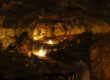
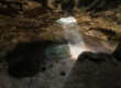
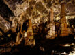
Idaho’s Mammoth Cave

Planning a trip to Idaho? Don’t forget to put Idaho’s Mammoth Cave at the top of your list. As a top attraction in the state, you can explore a unique and awe-inspiring underground landscape at your own personal pace with our self-guided tours. In addition to the cave, there are two privately owned museums of natural history on-site, the Shoshone Bird Museum and the Richard Arthur Olsen Museum, featuring a wealth of exhibits that has earned the nickname “The Smithsonian of the Desert,” making it an unforgettable stop for the whole family.
Located eight miles north of Shoshone, Idaho, on Highway 75, Idaho’s Mammoth Cave will be open for seasonal tours from May – October, from 10 a.m. to 6 p.m (with the last tours of the day going out at 5 p.m), 7 days a week, including all major holidays. For more information, visit idahosmammothcave.com or call (208) 329-5382.